Settings
This is where you set movement speeds, adjust how realistic the simulated GPS signal looks, choose which controls appear in the widget, set roaming defaults, and back up or restore your data.
Movement & GPS · Anti-cheat warning · Map · Menus · Favorites & Routes · Roaming · External services · QR transfer · Export / import
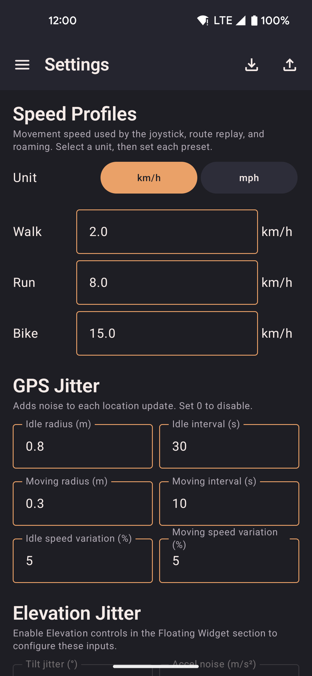
- Movement & GPS lets you edit the Slow Walk, Walk, Run, Bike, and Drive speed presets used by the joystick, routes, and roaming, and turn GPS realism features on or off one by one: bearing hold, altitude drift, warm-up, satellite count, and signal dropouts.
- Menus lets you choose which features appear in the floating widget and on the map, and drag to reorder them.
- Favorites & Routes lets you turn on curated locations and routes for quick access.
- Roaming lets you set defaults for Walk around the block (area, distance, speed, road-following, auto-return) and for Planting (starting and ending radius, Bike by default, infinite loop or number of loops).
Movement & GPS
This screen combines speed settings with GPS realism controls. Set your movement speeds here, and adjust how the simulated signal behaves.
Speed profiles
Five presets control movement speed for the joystick, route playback, and roaming. Edit any of them, and the change applies right away, including during a playing route or roam. A km/h ↔ mph switch at the top converts every speed shown in the app at once.
| Profile | Default | Pace |
|---|---|---|
| Slow Walk | 1.1 km/h | Strolling, browsing shopfronts |
| Walk | 2.0 km/h | Regular walking pace |
| Run | 8.0 km/h | Jogging, follows footpaths when road-following is on |
| Bike | 15.0 km/h | Cycling, follows bike lanes when road-following is on |
| Drive | 54.0 km/h | Driving, well above the anti-cheat threshold below |
There's no upper limit, so you can type any speed you want. The only floor is 0.04 km/h: anything entered below that gets raised to it automatically, since a true zero would mean the simulated device never moves at all.
Each profile also has a checkbox that controls whether the widget's Speed cycle button includes it. Walk, Run, and Bike are on by default, while Slow Walk and Drive are off unless you turn them on. This only affects cycling: all five speeds stay editable here no matter what.
Anti-cheat warning
Set any profile above 28.8 km/h (17.9 mph) and a warning appears inline below that field:
"Speed exceeds 8 m/s, may trigger anti-cheat in some games"
This is informational only — nothing is blocked or altered. The threshold sits just above any realistic human walking or running pace. Each profile is checked on its own, so lower it below the threshold to clear the warning, or ignore it if that's not something you need to worry about.
Location randomness
Adds small random variation to each location update, mimicking the natural drift of a real GPS chip. Set any value to 0 to turn off that particular variation.
| Option | Applies | What it does |
|---|---|---|
| Idle radius | Stationary | The largest random offset while you're standing still. 1 to 3 m looks like a real chip drifting slightly in place. |
| Moving radius | Moving | The largest random offset while moving. Keep it below the idle radius to avoid unnatural-looking jumps. |
| Max step per tick | Always | How far the jittered position can move in one second. Higher values look like a faster drift; lower values look like a slow wobble. |
| Idle speed variation | Stationary | A random percentage added to or subtracted from the reported speed at rest. 5 to 10% mimics normal measurement noise, while 0 reads as perfectly still. |
| Moving speed variation | Moving | A random percentage added to or subtracted from the reported speed while moving, so it doesn't look like a flat, constant number. |
| Altitude variation | Always | How much the reported height drifts up and down. Larger values look bumpier; set it to 0 for a perfectly flat height (the "Vary altitude" switch below still needs to be on). |
GPS realism
These toggles work independently to make the spoofed GPS signal behave more like a real hardware chip. Some apps and games check these details to spot fake locations, so turning on all the options lowers the chance of being detected.
| Option | Default | What it does |
|---|---|---|
| Hold bearing when stationary | On | Keeps reporting your last direction instead of snapping back to north when you stop. A sudden reset to north is a common giveaway. |
| Vary altitude | On | Drifts the reported altitude slightly rather than holding one constant height. How much it drifts is set by the "Altitude variation" field above. |
| Use real-world elevation | On | Looks up the actual ground height at your spoofed spot every minute, instead of a fixed ~35 m, and eases toward it gradually rather than jumping. Needs an internet connection; falls back to the fixed height if the lookup fails, and pauses automatically while an altitude override (below) is active. A "Reset elevation override" button clears an active override and lets this resume. |
| Show altitude override button | Off | Adds a button to the floating widget for typing in a fixed height from anywhere, overriding both the default and the real-world lookup until reset. |
| GPS warm-up simulation | Off | Starts each session with lower accuracy that sharpens over about 30 seconds, like a phone getting its first GPS fix. |
| Realistic satellite count | On | Reports 7 to 14 visible satellites, with 6 to 12 actually in use. Zero satellites is a giveaway some apps check for. |
| Suspended mocking | Off | Cycles between normal jittery movement and a brief stationary pause to mimic real signal dropouts — still reports every second so nothing goes stale, it just holds still during the pause. Turns off automatically during route playback and walking. |
Map
Controls how the map inside the app behaves while spoofing is active.
| Option | Description |
|---|---|
| Remember last location | Brings back your most recent spoofed position when you reopen the app, so you don't have to re-enter coordinates. Your position is saved on your device after every update. If nothing is saved yet, the app starts from your phone's real location instead, whether this option is on or off. |
| Follow location on map | Keeps the map centered on your spoofed position as it moves. Panning the map by hand turns this off until you tap the re-center button. |
Menus
Appearance
A Light mode switch lets you flip the whole app to a bright, high-contrast look instead of the default dark orange-on-black theme, handy for reading the screen outdoors in bright sunlight. The change applies immediately in the app and in the floating widget's lists and route options. The small round buttons that sit over other apps stay dark with bright icons so they stay easy to see either way. Loop, reverse, return, follow roads, and planting stay readable in both looks.
Map
The Map source switch picks where map images come from, for the map screen, the floating map, the favorites picker and the route creator together. OpenStreetMap is the default. Amap (高德) is much faster and more detailed in mainland China, where OpenStreetMap tiles are often slow or blocked.
Amap draws its map in China's GCJ-02 coordinate system, which is deliberately shifted from real GPS by a few hundred metres. The app converts on the fly so markers, routes and taps still land on the right spot, and everything you save, share or spoof stays in standard GPS (WGS-84) coordinates, so switching back and forth never moves your data. A small credit in the map's corner tells you which source is active.
Choose which quick-access features appear in the floating widget and on the map screen, and in what order. Each feature has its own checkbox for the widget and for the map, so you can turn either on independently, plus a drag handle on the left so you can reorder the whole list. Both surfaces follow the same order, so reordering once keeps everything consistent between them.
| Feature | Icon | Description |
|---|---|---|
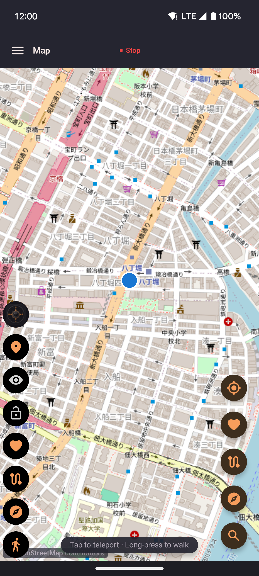
| Map shortcut | 📍 | Only available in the widget. Opens a compact map that fills the screen without switching back to the main app. Supports walk-to, teleport, and roaming controls right there. |
| Show/hide joystick | 👁 | Only available in the widget. Shows or hides the floating joystick on its own, without needing lock. While a route is playing or roaming is running, the button fades but still shows or hides the joystick. |
| Lock joystick | 🔒 | Only available in the widget. Shows the joystick if it is hidden, then holds the joystick's direction after you let go, so the simulated device keeps moving without you touching the screen. Tap again to unlock. While a route is playing or roaming is running, the button fades but still shows and locks the joystick. |
| Favorites | ❤️ | Available in both the widget and the map. Lists your saved favorite locations with one-tap teleport and walk shortcuts. From the widget, you can also save your current spoofed position as a new favorite. |
| Routes | 🗺 | Available in both the widget and the map. Lists all your saved routes, with options to start, loop, reverse, or return them. While a route is playing, the button expands to show pause and stop controls. |
| Roaming | 🧭 | Available in both the widget and the map. Opens Walk around the block and Planting so you can start a random walk or a spiral around where you are now. On by default in both places, including after an update from an older version. |
| Search | 🔍 | Only available on the map. Opens the search bar so you can find and jump to a place by name. |
| Paste coordinates | 📋 | Available on the map and the floating widget. Opens a box to paste coordinates such as 11.0127769, 79.48065 or 37°34'11.4"N 127°00'17.9"E. The box grows up to 10 lines, then scrolls, with the edges fading so you can tell there is more; Select all and Clear all sit under it. Teleport, walk, or save the first point as a favorite. With two or more points you can save a named route or start playing them, including loop, reverse, return, follow roads, and planting. On the widget the box sits at the bottom so you can switch apps to copy more points, and you can shrink it to a bar. Off by default; turn it on here to show it on the map, the widget, or both. |
| Capture coordinates | 📍+ | Opens from Home or the side menu. Collect map links from other apps into a list, then save them as a route. Capture itself is off until you turn it on there. The floating widget is not required. |
| Speed cycle | ⚡ | Only available in the widget. Cycles through your enabled speed profiles with a single tap; you choose which ones below. The icon changes to show the active profile. After a route or roam has started, this button takes over from the speed that session began with. |
Starting and stopping location simulation is always available from the bar at the top of every screen, so it isn't one of the configurable features above.
Hide teleport features
A single switch that removes every "jump straight to a location" option across the app — on the map, in favorites, when starting a route (including Teleport between waypoints), in Group Sync, in the paste box, and in the floating widget. Starting a saved route or starting pasted points then walks to the first stop instead of jumping there. Turn it on if you only want to move around by walking. It's off by default.
Hide notification icon
Removes the status bar icon for the "Mock location active" notification while spoofing runs. Android requires the notification to keep existing — this just tucks it into the notification shade instead of showing it persistently. Off by default.
Show route jump buttons
Adds "Previous stop" and "Next stop" buttons while a saved route is playing, letting you jump straight to the next or previous stop instead of walking the distance between them. With Teleport between waypoints on, you land on that one stop and wait there for the same delay as the automatic jumps, then playback continues. On by default, and hidden entirely when Hide teleport features is on.
Debug stats
Shows a live readout of your coordinates, speed, altitude, accuracy, heading, and update rate right inside the floating widget panel while it's expanded. Handy for checking that spoofing is behaving the way you expect. Off by default.
Favorites & Routes
Add ready-made locations and routes to your lists with one tap.
| Option | Description |
|---|---|
| Show hot locations | Adds a curated list of well-known city centers, parks, and landmarks into your favorites. Off by default. Turning it off removes only the entries this feature added; your own favorites are never touched. See Favorites → Hot locations for the full list and how updates work. |
| Show hot routes | Adds a curated set of ready-made routes for popular event locations into your routes list. Off by default. Turning it off removes only the routes this feature added; your own routes are never touched. See Routes → Hot routes for the full list and how updates work. |
Roaming
Set defaults for Walk around the block and Planting. Only one of those modes can run at a time.
| Option | Description |
|---|---|
| Walk around the block — Radius | The farthest distance from the starting point that random waypoints can land. Larger values spread movement further from the center. |
| Walk around the block — Route distance | The total distance to walk before the roaming session ends. It stops once the distance walked adds up to this value. |
| Walk around the block — Speed | Which speed preset Walk around the block starts at. Walk, Run, and Bike are available from the roaming sheet; Settings also keeps Slow Walk and Drive. Default Walk. After roaming starts, changing speed in the app or on the widget takes over. |
| Follow roads | Walk around the block only. Routes each leg through a road-mapping service so movement follows real walkable paths instead of straight lines. Falls back to a straight line if that service isn't available. |
| Return to start | Walk around the block only. After the main roaming loop completes, the simulated device walks back to the original starting position. |
| Planting — Starting radius | How close in the spiral starts, in meters. Default 5 m. |
| Planting — Ending radius | How far out the spiral opens before it tightens back in, in meters. Default 39 m. |
| Planting — Speed | Which speed preset Planting starts at. Walk, Run, or Bike. Default Bike, independently of Walk around the block. After it starts, changing speed in the app or on the widget takes over. |
| Planting — Infinite loop | Keeps expanding and contracting until you stop roaming. Turn this off to set a number of loops instead. One loop is one full expand and contract. |
External services
locationjoystick works offline by default. It doesn't need an account, and it doesn't send any usage data or tracking information anywhere. That said, two optional features do reach out over the network:
| Service | When used | What is sent |
|---|---|---|
| OSRM router.project-osrm.org |
Road-following routes, roaming with Follow roads turned on, and guided route creation. This service is only contacted when you specifically choose road-following. | A list of latitude and longitude pairs, your waypoints or random roaming targets. No device identifiers and no account data are sent. The public demo server used for this is run by the OSRM project. |
| Nominatim nominatim.openstreetmap.org |
Place-name search in the route creator and the favorites map picker. Only contacted when you type a search query. | Whatever text you type into the search box, a place name or address. No GPS coordinates and no identifiers are sent. The public search service used for this is run by the OpenStreetMap Foundation. |
Map images come from OpenStreetMap and are fetched from tile.openstreetmap.org as you pan and zoom the map. Each request includes only the map tile's position, its zoom level and grid coordinates, and no personal data.
All three services are contacted only when the feature that needs them is in use, and you can avoid all of them entirely by not using road-following, place search, or the map itself, for example by entering coordinates directly into Favorites.
QR transfer
Share your whole configuration between two devices by scanning a single QR code, without a cable, an account, or any cloud service involved.
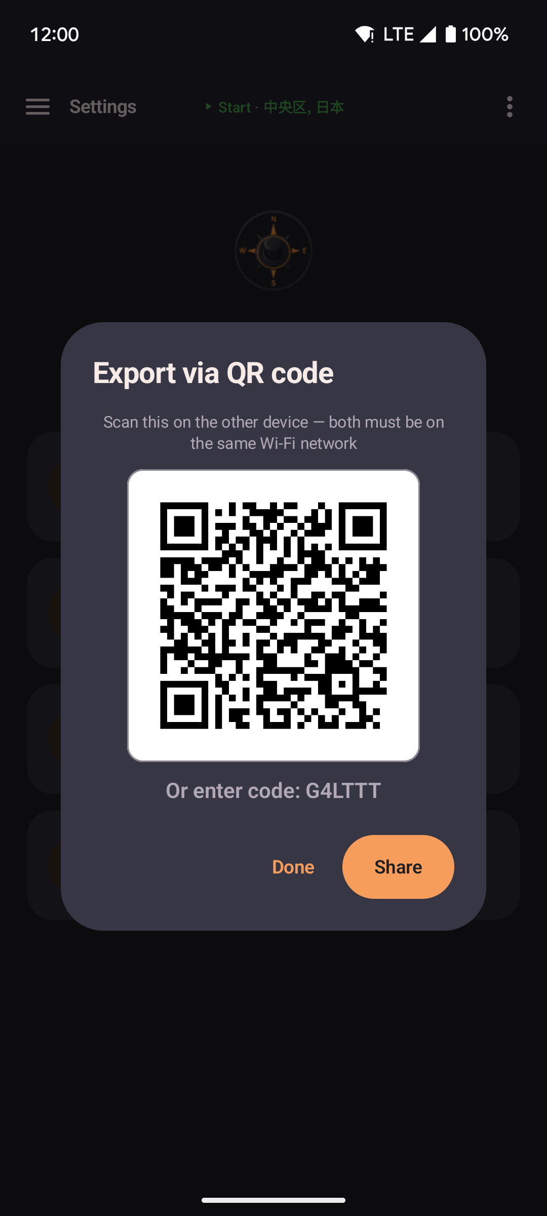
- Both devices need to be on the same Wi-Fi network.
- The sending device shows a QR code, plus a short backup code. The receiving device scans the code, or types it in, and imports right away.
- The data travels directly between the two devices — see the privacy policy for the app's no-cloud stance.
Export / import
Back up or restore all of your app data: routes, favorites, speed profiles, widget setup, location randomness settings, and roaming defaults.
| Action | Description |
|---|---|
| Export via QR code | Shows a QR code that another device on the same Wi-Fi network can scan to receive your current configuration. |
| Export settings | Saves a backup file to your device, which you can share or keep as you like. |
| Import from QR code | Opens the camera to scan a code shown on another device on the same Wi-Fi network, then asks whether to add it to your existing data or replace everything. |
| Import via code | Type in the short code shown on the sending device instead of scanning. Both devices still need to be on the same Wi-Fi network. |
| Import from file | Opens a file picker so you can choose a previously exported backup file. Asks whether to add it or replace everything. |
| Import from GPS Joystick | Choose a GPX file exported from GPS Joystick. Named saved places become favorites, and each route is imported as straight-line segments. Routes with thousands of points are skipped, and a message tells you how many. Database backup files from that app are not used — export GPX instead. |
| Import from YAMLA | Migrates favorites and speed settings from a YAMLA export file. |
Next to the export and import buttons is a Reset all data button. It asks you to confirm first, then permanently deletes all your favorites, routes, and settings, without you needing to clear the app's data through your phone's own settings. Your permission grants stay in place, so you won't have to go through setup again.